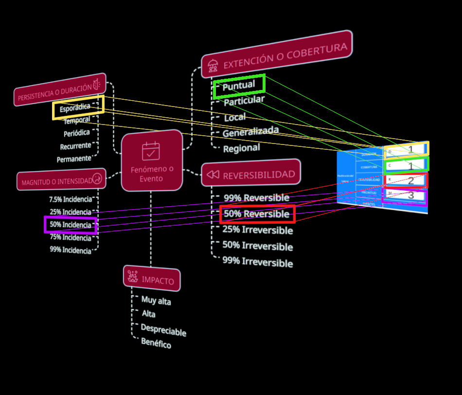
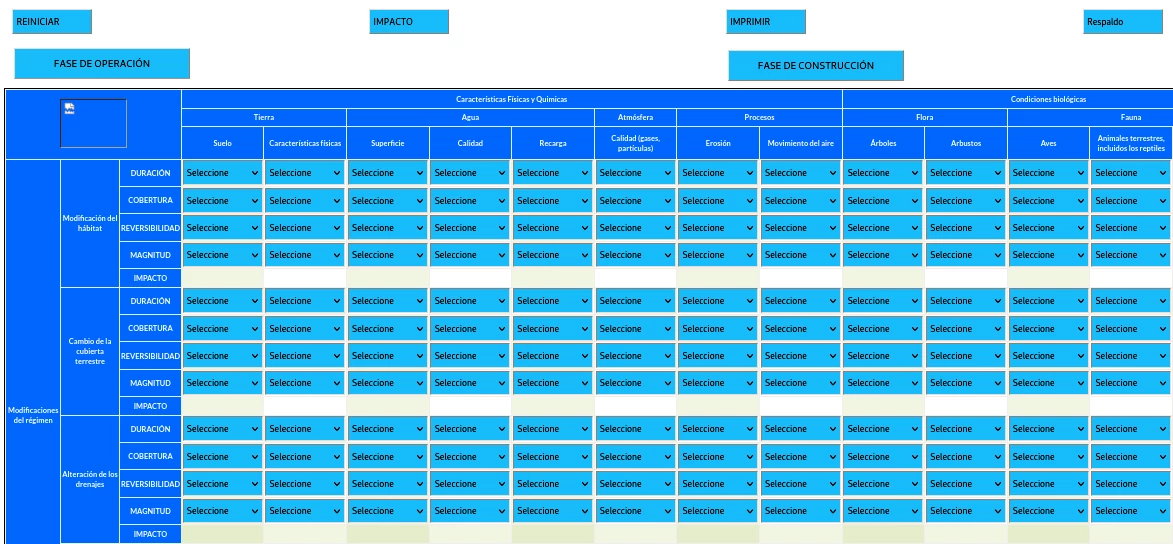
The environmental and socio-cultural impact assessment (EIAsc) is excellent for assessing the potential environmental consequences of a project or activity before it is carried out using the digitized leopold matrix to convert its quantitative results into statistics avoiding human errors of omission the matrix can and does use the percentage as the universal unit of measurement for the results and it is not mandatory to fill in all cells.
DESCRIPTION FOR THE SELECTION OF THE AREA TO OCCUPY
1st- Select the range of 10 to 10.000.000 Hectares that best fits the area.
2nd- You can request only the Elaboration of Leopold matrix where you will receive by mail ZOOM (DHL) the form printed on a double letter sheet (tabloid) to place in each cell or box the corresponding number of the “VARIABLES TO FILL IN ACCORDING TO THEIR NUMBER” always following the procedure of the Guide, then you must return the scanned sheets to the mail [email protected] or by mail ZOOM (DHL).
The real-time result will be sent by mail or by zoom within 3 days.
AVAILABLE SERVICES, Requires you to enter the coordinates in UTM format and separated by comma.
1.- Productive capacity of the soil
2.- Relative soil moisture
3.- Land use change
4.- Forest cover
5.- Urban environmental quality
6.- Geologic (geomorphology) census
7.- Request to prepare environmental impact study
QUALITY CONTROL
The Leopoldo matrix is one of the few that can be digitized.
10 meter by 10 meter resolution for hyperspectral imaging.
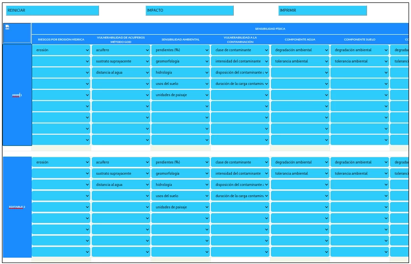
Perform sensitivity diagnostics and environmental characterization like never before, ergonomic design and user friendly environment, error reduction of less than 0.1%, get the agility and ease to get amazing automated environmental sensitivity results, the spaces are fully EDITABLE.
You will get a complete image in maximum quality, showing all the specific details of the matrix.
The results are automatically saved.
DESCRIPTION OF PRODUCTIVE CAPACITY OF THE SOIL
You will know how viable it is to invest or how much you can invest according to the project and how fertile the soil is.
The real-time result will be sent by mail or by zoom within 36 to 72 hours.
DESCRIPTION OF RELATIVE HUMIDITY PERCENTAGE
With the percentage of relative humidity of the soil, the areas with more or less water deficiency are estimated and a good measurement is supported. You will know the amount of relative humidity necessary for the correct distribution of water.
The real-time result will be sent by mail or by zoom within 3 to 7 days.
DESCRIPTION OF LAND USE CHANGE
You will know the type and texture of the soil, detailed information is provided on total infiltration volume and the ability to compare possible rainy season runoff niels with precise amounts so that you can evaluate and mitigate.
The real-time result will be sent by mail or by zoom within 3 to 7 days.
DESCRIPTION OF FOREST COVER
You will know the dynamics of changes for production and conservation in land cover, the percentage of forest, non-forest, deforestation rate and its cause.
The real-time result will be sent by mail or by zoom within 3 to 7 days.
DESCRIPTION OF URBAN ENVIRONMENTAL QUALITY
To understand the human and environmental factors that affect environmental quality, availability of public space, quality and quantity of green areas, air pollution, infrastructure quality, housing availability, mobility and public service transportation.
The real-time result will be sent by mail or by zoom within 3 to 7 days.
DESCRIPTION OF GEOLOGIC CENSUS
Request this service if there are potential ferrous, argillaceous and iron oxide ore zones in the mining exploration stage.
The real-time result will be sent by mail or by zoom within 3 to 7 days.
DESCRIPTION OF REQUEST TO PREPARE ENVIRONMENTAL IMPACT STUDY
We carry out the management and elaboration of sensitivity, characterization and environmental impact before MINEC. Socio-economic information of the area will be requested.
The real-time result will be sent by mail or by zoom within 35 days.


Reviews
There are no reviews yet.